The River Valencia Turned Into a Park
Essay
In 1957 the Turia drowned Valencia. The city moved the river out, planned motorways for the empty bed, and was talked out of them by its own citizens. The story of the Turia Garden runs from Roman irrigation to a dictator's stamp tax, a fallas artist's giant and the night in 2024 when the new channel held.
Viacheslav Munister · 2026-09-20
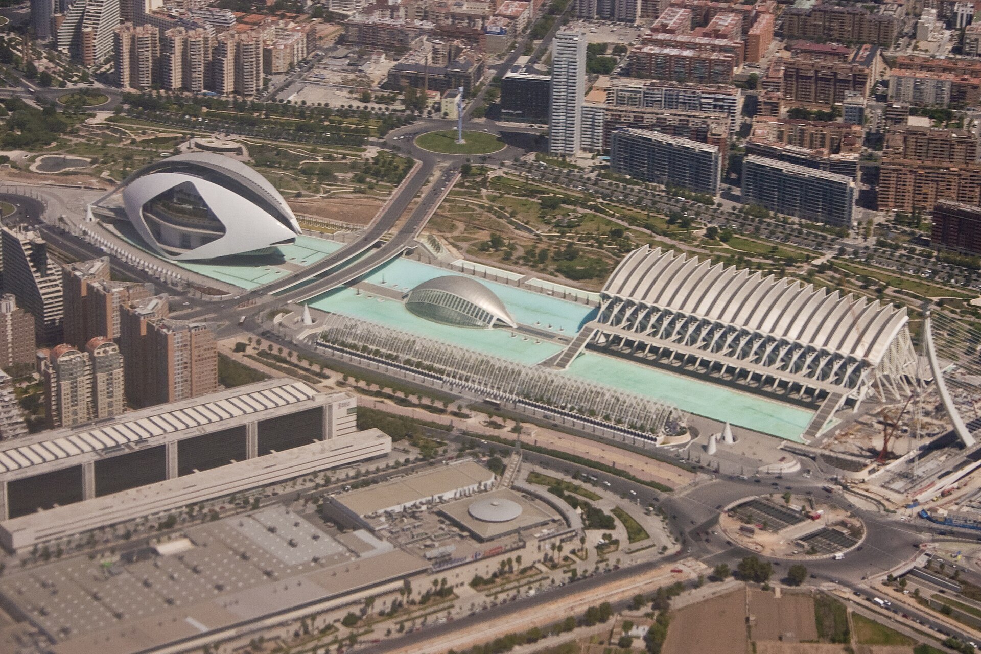
In the middle of Valencia there is a river with no water in it. Its stone embankments are still there, and so are its bridges, some of them standing on foundations more than four centuries old, but below them, where the Turia once ran, there are orange trees, football pitches, a running track, ponds, a concert hall and a giant lying on his back while children slide down his hair. The Jardí del Túria follows the old riverbed for about eight and a half kilometres, dropping from 19 metres above sea level at the zoo on the western edge of the city to one metre at the Oceanogràfic near the port.
It looks like a gift of nature. It is the opposite: the product of a disaster, a colossal piece of engineering, a road plan that was never built and a civic campaign that insisted a city could decide for itself what to do with its own scar. Few public spaces in Europe explain so clearly how a city is actually made.
A river the city was built around
The Romans founded Valentia in 138 BC beside the Turia, and for the next two thousand years the city lived from the river and in fear of it. Its water fed the acequias, the irrigation channels of the Horta, the market gardens that surround Valencia; the farmers who share that water still settle their disputes every Thursday at the Water Tribunal outside the cathedral, one of the oldest courts of justice in Europe. From the fifteenth century a special municipal body, the Fàbrica Vella de Murs i Valls, built and maintained the stone parapets that still line the riverbed. They did not stop the floods. Valencians named them after the saints on whose days they came, the flood of Saint Michael, of Saint Martin, and historians count dozens between the fourteenth and nineteenth centuries. One of them, in 1589, swept away the bridge to the sea; its stone replacement, the Pont del Mar, was built in 1591 and still stands.
October 1957
The flood that changed the city came after three days of a gota fría, a cold drop, in October 1957. Rain fell on Valencia and the mountains upstream from Saturday the 12th; the river rose on the 13th and, after torrential rain around midday on Monday the 14th, burst into the city. The old centre around the cathedral largely escaped, but newer districts such as Zaidía and Campanar were devastated, in Marxalanes some streets stood under five metres of water, and Natzaret, by the port, was cut off. Valencia was left without water, gas or electricity; around 5,800 homes were destroyed, some 3,500 families lost their homes, three quarters of the city's commerce and industry stopped, and at least 81 people died.
Franco visited the city on 24 October and promised government money. It was slow to come, and the mayor said so. Tomás Trénor Azcárraga, who by an unkind coincidence held the title Marquis of the Turia, protested in public about the missing aid. In 1958 he was removed from office, and with him the editor of the newspaper Las Provincias, Martín Domínguez Barberá, and the president of the Ateneo Mercantil, Joaquín Maldonado. The regime would rebuild Valencia, but on its own terms.
Moving a river
Engineers had studied the problem for years; the architect Fernando García Ordóñez had been working on alternatives since 1946. After the flood, the minister Vicente Mortes commissioned a detailed study of three options. The Northern solution would have joined the Turia to the Carraixet ravine; the Central one would have improved the existing course and added a reservoir upstream at Vilamarxant. The Southern solution was the most expensive and the most colossal: to dig an entirely new river across the Horta, from Quart de Poblet to the sea near Pinedo. The Council of Ministers chose it on 22 July 1958, and a law of 1961 set out how it would be paid for, including a detail every Valencian of that generation remembers: for as long as the works lasted, every letter and parcel posted in Valencia carried an extra 25-céntimo stamp for the river.
Work under the Júcar River Basin Authority began in the mid-1960s. Franco inspected the finished channel on 22 December 1969, and by around 1973 the Turia no longer ran through the city. The new course is 11,868 metres long, 175 metres wide for most of its length and 200 metres near the sea, and was designed to carry 5,000 cubic metres of water a second. Its banks became a ring road, today's V-30. And in the middle of Valencia it left a long, dry, empty space, which the plans of the 1960s had already assigned to motorways and a transport axis linking the port and the airport.
The riverbed is ours
The motorway was never built, for two reasons that reinforced each other. The ring road along the new channel made a highway through the centre less necessary. And the city began to argue. From 1973 Las Provincias ran campaigns defending the riverbed, its five-hundred-year-old parapets and its bridges as heritage. Neighbourhood associations, in one of the first examples of organised citizen participation in Francoist Valencia, took up a slogan that is still painted into Valencian memory: El llit del Túria és nostre i el volem verd, the Turia riverbed is ours and we want it green. In 1976, a year after Franco's death, a decree signed by King Juan Carlos transferred the old bed to the city. In 1979 it was formally designated as green space and a public park.
What to plant there was another question. In 1981 the city commissioned a plan from Ricardo Bofill's Taller de Arquitectura, but only part of it was built; the final scheme approved in 1984 divided the riverbed into eighteen numbered sections, from Mislata to Natzaret, and gave them to different teams. Work began in 1985, and the first sections opened to the public in 1986 and 1987.
Bofill's own section is the most monumental: orange trees, palms, water and white neoclassical colonnades in front of the Palau de la Música. The concert hall was built under a national plan of 1983 to give every Spanish region an auditorium, and the site chosen for it, beside sections X and XI of the future garden, was a derelict industrial plot known as la Azufrera, the sulphur works. José María García de Paredes designed a glass-vaulted building that opened in 1987 and sits in the riverbed like a winter garden; Eduardo de Miguel extended it in 2003.
The rest of the garden changes character every few hundred metres, because it was designed by many hands. Vetges Tu i Mediterrània laid out sports pitches, meadows and fountains between the Casa del Agua and Nuevo Centro; the regional agriculture department planted an urban forest of thousands of pines between Nuevo Centro and Serranos; the architects Otegui, Gisbert and Noguera and the landscape architect Ángel Zurilla shaped further stretches. What holds it together is the one thing no designer invented, the line of the old river. Today the garden covers about 136 hectares, with an average width of 160 metres; the last sections towards the port, where groundwater still seeps into the old bed, are unfinished, and when they are done the park will be almost ten kilometres long and 160 hectares in size.
A giant for the Lilliputians
In 1986 the city and the regional government commissioned a playground under a programme called Un riu de xiquets, a river of children. The architect Rafael Rivera and Manolo Martín, an artist who built falles, the enormous satirical figures Valencia burns every March, produced a design by Sento Llobell: Lemuel Gulliver, seventy metres long, tied to the ground at the moment he wakes in Lilliput. Children become the Lilliputians, climbing his coat, sliding down his hair and hiding in his pockets. It cost 220 million pesetas, entry is free, and after a renovation it reopened in November 2022. It is a playground, and also a quiet joke about the whole project: a city discovering what to do with a space that had suddenly become far larger than itself.
Crossing a river that isn't there
Because the garden is still a river in the city's mind, Valencia crosses it on bridges, more than twenty of them. The Pont del Mar, with ten pointed arches and 160 metres long, was for centuries the road to the port; in 1933 it became a footbridge, with stairs by the architect Javier Goerlich, and when the garden was made a round pool was placed beneath its arches. The Serranos bridge leads to the medieval city gate. Santiago Calatrava, born in Valencia, built his first bridge here, the Nou d'Octubre in 1989, and later the Pont de l'Exposició above the Alameda metro station, which locals call la peineta, the comb, and the Assut de l'Or, known as el jamonero after the stand used to slice ham.
The eastern end belongs to Calatrava's City of Arts and Sciences, raised in the riverbed from the 1990s: L'Hemisfèric opened in 1998, the science museum in 2000, L'Umbracle in 2001, L'Oceanogràfic, with thin concrete shells by Félix Candela, in 2003, the Palau de les Arts in 2005 and L'Àgora in 2009. It became Valencia's postcard and one of its most argued-over projects: budgeted at around 300 million euros in 1991, it ended up costing about 1.2 billion. Seen from the garden, it reads as the loudest chapter of a story that began with mud in the streets.
October 2024
On 29 October 2024 another gota fría stalled over the region. The new channel of the Turia, dug after 1957, carried the flood past Valencia and the city centre stayed dry. South of it, the Poyo ravine, normally a dry bed running parallel to the river, rose past the maximum alert threshold of its single flow sensor; at 18:05 it registered almost 994 cubic metres a second, and the water poured through the towns of l'Horta Sud. More than two hundred people died in the province. In the following days thousands of volunteers walked from Valencia to the flooded towns across a footbridge over the new channel; it has since been named the Pont de la Solidaritat. Some experts point out that the channel protected the capital but not the wider plain around it, and that the lesson of 1957 was learned for one river rather than for the whole landscape.
What the garden teaches
The Turia Garden is usually described as a park. It is closer to an argument about what a city owes the people who live in it. The same empty bed could have become a fast road between the edges of Valencia; instead it became a slow line joining its neighbourhoods, where people walk, run and cycle from one end of the city to the other without meeting a car, and where the old bridges still frame views of a river that is no longer there.
Many cities now try to uncover buried rivers, tear down urban motorways or turn railway lines into parks. Valencia did something similar half a century ago, before it was fashionable, and for a reason that 2024 made painfully clear: people who had lived through a flood asked that the place of the disaster be given back to them green. The water was sent elsewhere. The memory stayed in the riverbed, and the city chose to walk through it every day.
Text: Viacheslav Munister for EPRIS Journal. Sources include the Spanish Wikipedia entries on the Plan Sur, the Jardín del Turia, the Parque Gulliver, the Palau de la Música and the October 2024 floods, and the Colegio Territorial de Arquitectos de Valencia. Photographs: Wikimedia Commons, authors and licences are given with each image.